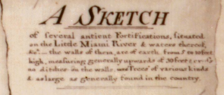
http://www.econ.ohio-state.edu/jhm/arch/efw.html
Ohio's East Fork or "Hanukkiah" Earthworks
National Archives Photograph RG77 144.20
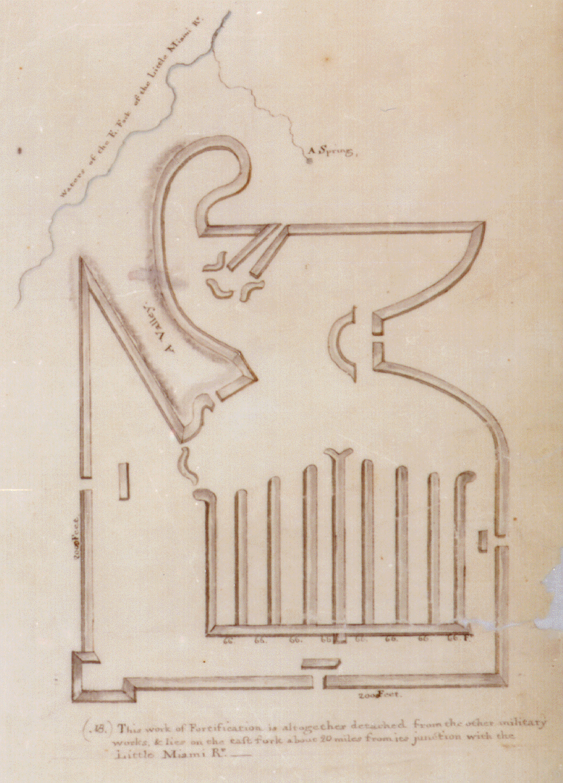
The ancient Ohio earthworks depicted above once lay along waters of the East Fork of the Little Miami River, about 20 miles above its mouth near Milford, and about 25-30 miles east of Cincinnati. The base and left side walls were each 2000 feet long. They have long since been plowed level, and their orientation and exact location are unknown.
Ohio had dozens of such large-scale earthworks, attributed to the Hopewell Culture of circa 100 BC to 500 AD. However, most of them incorporated relatively simple geometrical structures, primarily circles, squares, octagons, and extended parallel walls. The East Fork Works are unusual for their complexity.
The above map of the East Fork Works was drawn in 1823 by Maj. Isaac Roberdeau, head of the Bureau of Topographical Engineers, U.S. Army Corps of Engineers. The complete original map, depicted below, is preserved in the Cartographic and Architectural Branch of the Military Archives Division of the U.S. National Archives in Alexandria, Va., Record Group 77 (U.S. Army Corps of Engineers, Fortifications File), drawer 144, sheet # 20. The 5" scale at the lower left represents 2000 feet. A less detailed survey of the same works depicted on the Roberdeau map, made circa 1803 by Gen. William Lytle of Cincinnati, had previously been published in Hugh Williamson's 1811 Observations on the Climate in Different Parts of America.
National Archives Photograph RG77 144.20
Click above for blowup of legend.
In an important new book entitled Jefferson and the Indians: The Tragic Fate of the First Americans, Anthony F.C. Wallace, University Professor of Anthropology, Emeritus, at the University of Pennsylvania, notes that in 1803, President Thomas Jefferson was impressed by William Lytle's early maps of the East Fork and Milford Works, and requested more information about "Those works of Antiquity" (p. 139 and n. 18). Wallace includes a copy of Lytle's map of the East Fork Works, alongside a photograph of the more detailed 1823 Corps of Engineers map presented above (pp. 140-1).
Jefferson's Presidential interest in these specific earthworks may explain why the Corps of Engineers would have taken the trouble in 1823 to map structures that had no conceivable contemporary military value. The fact that the 1823 map depicts precisely those earthworks surveyed by Lytle c. 1803 strongly indicates that there was a more than coincidental link between the two surveys.
Roberdeau's 1823 map is the ultimate source of Panel 2B of Plate 34 of Squier and Davis's 1848 Ancient Monuments of the Mississippi Valley. In 1894, Cyrus Thomas, who was unaware of this primary source, dismissed the Squier and Davis diagram as "largely imaginary." In 1902, Gerard Fowke likewise indicated that the "interior arrangement" induced "some scepticism as to the accuracy of the drawings." Fowke rotated the Squier and Davis illustration 90 degrees, and nicknamed the structure the "Gridiron".
Thomas and Fowke did not indicate precisely what it was about the East Fork Works that they found so questionable. More recently, however, David Berry of Columbus, Ohio has noted that the structure inside the walls looks remarkably like a Hanukkiah (or Hanukiah, or Channukiah, etc), the nine-branched candelabrum or menorah used to celebrate the Jewish festival of Hanukkah (or Hanukah, or Channukah, etc). Eight of the nine candles of the Hanukkiah represent the eight days an oil lamp is supposed to have miraculously burned, despite the fact that it was filled by a jar that had only enough oil for one day, after an historical seige of Jerusalem was lifted in 165 B.C. by Judah Maccabbee. The ninth candle, the shammes or "servant," traditionally stands either higher than or aside from the other eight, and is used to light the others on the eight days of Hanukkah. It might be added that the upper portion of the outer structure of the East Fork Works bears a curious resemblance to an ancient oil lamp.
Squier and Davis obtained their information from an intermediate, secondary source published in French by the American geographer David Baillie Warden. They were unaware of Roberdeau's original map. This primary source demonstrates that, despite the objections of Thomas and Fowke, Squier and Davis did faithfully depict the earthworks themselves. However, it also shows that they and Warden added terrain features to Roberdeau's original map that may in fact be imaginary. Traces of the mound's outline might still be visible from the air, if a concerted search for it were made. The "Gridiron" name for the structure indicates, if nothing else, that Fowke had more interest in football than in ancient history.
For full details, see J. Huston McCulloch, "Ohio's 'Hanukkiah Mound'," Ancient American, Vol. 3, # 14 [Sept/Oct 1996], pp. 28-37, a PDF of which is now online.
If you have a fast modem, click here for a blowup of the East Fork works (503 KB) . For maximum field of view, enlarge your window to full screen. If you are using Netscape, you might want to use the OPTIONS menu to deselect SHOW TOOLBAR, SHOW DIRECTORY BUTTONS, and/or SHOW LOCATION. If you deselect the TOOLBAR, you can still return to this screen by selecting GO/BACK.
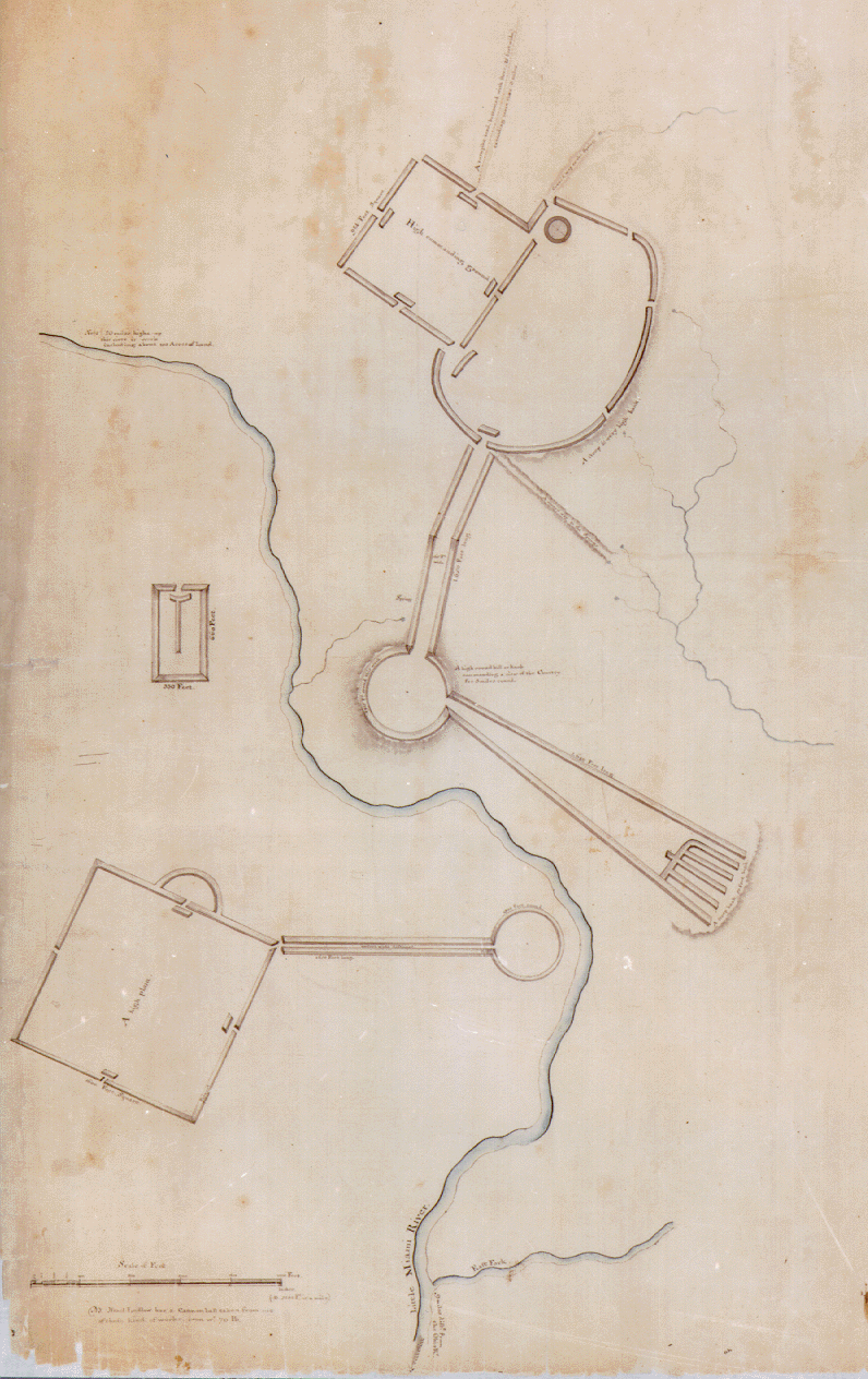
The Milford Group
The left portion of the full map, displayed above, represents the Milford Group, also depicted in Panels 1 and 2a of Plate 34 in Squier and Davis. Although north is not indicated, it must be about 70 degrees counterclockwise from the top for this portion of the map in order to place the East Milford Works (the smaller square and irregular circle) in their known orientation. The principal river is identified as the Little Miami, and the river joining it at the bottom is identified as its East Fork.
This primary source demonstrates that Squier and Davis drew the extension and "wing" to the Milford Works on much too small a scale. The connecting circle must in fact have been on top of the high knoll in the center of Milford, and the "wing" must have extended into south Milford. They also detached the West Milford Works from the plan, and somehow inverted the original diagram in mirror image.
Click here for a blowup (486 kb) of the Milford Group .
Return to top of this page . Up to Archaeological Outliers Page .
Maintained and written by J. Huston McCulloch Send comments to: mailto:mcculloch.2@osu.eduLast revised 12/10/01Link to Ancient American article added 12/29/04
This page received 2548 visits, 11/15/04 - 12/26/05. Annoying free hitcounter removed, 12/26/05.
Subscribe to:
Post Comments (Atom)


No comments:
Post a Comment